


Damascus Voting District, Washington County, Virginia
About
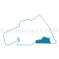
Outline

Summary
| Unique Area Identifier | 682677 |
| Name | Damascus Voting District |
| County | Washington County |
| State | Virginia |
| Area (square miles) | 37.54 |
| Land Area (square miles) | 37.37 |
| Water Area (square miles) | 0.17 |
| % of Land Area | 99.55 |
| % of Water Area | 0.45 |
| Latitude of the Internal Point | 36.65253430 |
| Longtitude of the Internal Point | -81.74647980 |
Maps


Graphs
Select a template below for downloading or customizing gragh for Damascus Voting District, Washington County, Virginia


Neighbors
Neighoring Voting District (by Name) Neighboring Voting District on the Map
- 19H East Cherokee School Voting District, Sullivan County, TN
- 1A Laurel Voting District, Johnson County, TN
- 6B Sutherland Voting District, Johnson County, TN
- Green Cove Voting District, Washington County, VA
- Rhea Valley Voting District, Washington County, VA
Top 10 Neighboring County Subdivision (by Population) Neighboring County Subdivision on the Map
- Taylor district, Washington County, VA (7,503)
- District 1, Sullivan County, TN (6,876)
- District 1, Johnson County, TN (3,425)
- District 6, Johnson County, TN (1,018)
Top 10 Neighboring Place (by Population) Neighboring Place on the Map
Top 10 Neighboring Unified School District (by Population) Neighboring Unified School District on the Map
- Sullivan County School District, TN (84,038)
- Washington County Public Schools, VA (54,876)
- Johnson County School District, TN (18,244)
Top 10 Neighboring State Legislative District Lower Chamber (by Population) Neighboring State Legislative District Lower Chamber on the Map
Top 10 Neighboring State Legislative District Upper Chamber (by Population) Neighboring State Legislative District Upper Chamber on the Map
Top 10 Neighboring 111th Congressional District (by Population) Neighboring 111th Congressional District on the Map
Top 10 Neighboring Census Tract (by Population) Neighboring Census Tract on the Map
- Census Tract 9564, Johnson County, TN (4,876)
- Census Tract 109, Washington County, VA (4,233)
- Census Tract 110, Washington County, VA (3,416)
- Census Tract 108, Washington County, VA (3,133)
- Census Tract 431, Sullivan County, TN (3,080)
- Census Tract 9560, Johnson County, TN (1,018)
Top 10 Neighboring 5-Digit ZIP Code Tabulation Area (by Population) Neighboring 5-Digit ZIP Code Tabulation Area on the Map
- 37620, TN (39,102)
- 24211, VA (9,922)
- 24319, VA (6,979)
- 24340, VA (5,657)
- 24236, VA (3,085)
- 37688, TN (1,018)
- 37680, TN (766)